PHYSICAL OCEANOGRAPHY
ARVOR I, A NEW STEP FOR ARGO APPLICATIONS TO MARGINAL SEAS
Article written by Carole Saout-Grit – carole.saout@glazeo.net
CONTEXT
New requirements for the possible use of Argo floats in some areas have emerged in recent years, especially for marginal seas and coastal areas. The development of the Iridium communication on the new generation of ARGO floats was an important new technology step to allow using these floats in marginal or coastal seas, especially to reduce the risk of grounding, trawling or impacts in these seas of high marine traffic and sometimes low bathymetric.
Especially in marginal seas, an Italian consortium called ARGO-ITALY implements the means to contribute to long-term global observation networks such as ARGO, Euro-Argo, MEDARGO, GDP, EGO and SOOP for the Italian seas, the Mediterranean Sea and the Black Sea. The aim is to provide and maintain a sufficient amount of in-situ measurements of temperature, salinity, currents and biogeochemical water properties in these marginal seas hitherto little explored in long-term and in depth.
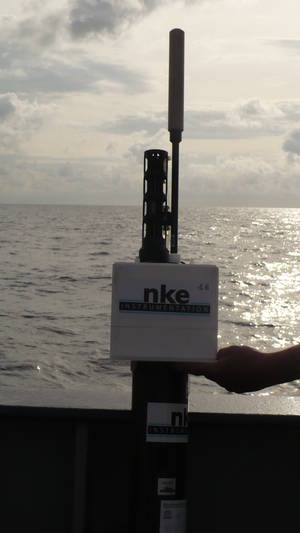
Figure 1 : ARVOR-I manufactured by NKE and deployed in the Ionian Sea from R/V Poseidon © OGS Italy april 2014
DATA
The new generation of ARVOR floats have been fitted since 2010 by NKE with a bi-directional Iridium communication , which considerably improved the duration of data transmission from the float on the surface. This new technological advance allowed a new capacity of modifying the mission parameters of the float during its cycle, thus making possible its use in marginal or coastal seas.
New improvements appeared also through the Iridium communication :
- transmission of new informations related to the behavior of the float
- a last CTD raw data is acquired before stopping the CTD pump at the end of the rising profile
- improved vertical resolution (2 dbars), improved power balance
- remote control available during operation (modification of cycling period, parking depth, profiling depth etc…)
- capability to manage seabed stationing proven at sea
One of the two first ARVOR-I has been deployed at sea in february 2010 in the Adriatic Sea (figure 2). The configuration of its mission parameters has been often modified, with a cycling period varying from 2 to 5 days, a profiling depth from 1200 to 800 meters and a parking depth at around 350 meters. He dead the 2/8/2014 after 327 cycles, a lifetime of 4.5 years and more than 250 kms during this period.
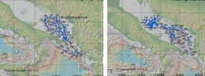
Figure 2: Trajectories of two ARVOR floats manufactured by NKE and deployed in the Adriatic Sea in 2010 and 2012 for the MedArgo program: (left-side) ARVOR-Argos #wmo 6901040, (right-side) : ARVOR-Iridium#wmo 1900848 ©GDAC CORIOLIS
Globally since summer 2010, 47 ARVOR-I floats have been deployed at sea, among which 30 are already active today (up to 15/10/2014). Those 47 floats allowed to collect more than 3500 vertical T/S profiles, mainly in the Med. Sea for 38 floats. 29 of those 38 Argo floats have been funded and deployed by the ARGO-ITALY consortium.
RESULTS
A recent publication of Bensi et al. (2013) uses the data of this float #1900848 together with the ones of an another Arvor also manufactured by NKE but equipped with an Argos transmission (#wmo 6901040). Both have been deployed in the southern part of the Adriatic sea between 2010 and 2012 for the MedArgo program.
The float data were used in the paper to integrate the oceanographic data obtained from the fixed platform E2-M3A, located in the centre of the southern Adriatic (see : http://nettuno.ogs.trieste.it/e2-m3a/). Indeed, merging eulerian and lagrangian measurements increases considerably the quality of the analysis for a specific topic, such as the spreading of the dense waters studied in Bensi et al., 2013. If we consider that the 2012 was characterized by an exceptional event of dense water production for the northern Adriatic, the importance of having constant measurements appears more clear.
Float #wmo 1900848 moved from the SAP (Southern Adriatic Pit) to the Pomo pit after October 2010, while the other float #wmo 6901040 remained in the SAP for several months (from April to July 2012), then it entered in the Ionian before a back in the SAP in January 2013 (see figures 2 et 3)

Figure 3 : Bathymetry of the Adriatic sea, with profiles positions and trajectories (red dots and lines) for the two floats #1900848 (since 01/01/2011 in the Pomo pit) and #6901040 (since 31/03/2012 in the SAP) . First (yellow stars) and last (yellow circles) profiles until 31/12/2012 © Bensi et al. 2013
Data collected from those two ARVOR allowed to analyze the large thermohaline changes which occured in the deep layer of the SAP after the arrival of dense waters formed on the northern shelf and in the Pomo pit during winter 2012. The recent work of Bensi et al (2013) show that during this winter 2012, dense waters called NAdDW (North Adriatic Dense Water, voir [Franco et al. 1982 ; Malanotte-Rizzoli et al., 1997] appeared in the northern part of the Adriatic Sea, under the combined effect of very strong, cold and dry northern winds and a low discharge of freshwaters from the Pô river and low rainfall.
After its generation phase, the NAdDW propagated quickly toward the Middle and Southern Adriatic, driven by its large density difference with adjacent water masses. Figure 3 show in details that during summer 2011, the NAdDW entrapped in the deepest part of the Pomo pit (100 m thickness layer above the bottom) with a density of 29.00+/-0.04 kg.m-3, while during summer 2012, its densité reached 29.44+/-0.16 kg.m-3.
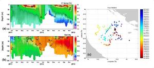
Figure 4 : Time-depth diagram of (a) Temperature and (b) Salinity obtained by the float in the Pomo pit from 1 January 2011 to 31 December 2012. Plot (c) shows the trajectory of the same float (s/n 1900848). © Bensi et al. 2013
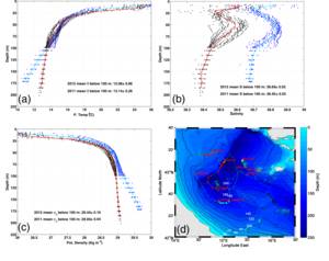
Figure 5 : Average (a)- Tmperature, (b)- Salinity, and (c) – potential density obtained from CTD float profiles collected in the Pomo pit (Middle Adriatic) in July-August 2011 (red) and July-August 2012 (cyan). Plot (d) shows the trajectory of the float 1900848 between July 2011 and December 2012 (red and cyan circles correspond to profiles collected in July-August 2011 and July-August 2012, respectively). © Bensi et al. 2013
REFERENCES
2013
Bensi M., Cardin V., Rubino A., Notarstefano G., and Poulain P.-M., 2013: Effects of winter convection on the deep layer of the Southern Adriatic Sea in 2012. Journal of Geophysical Research Oceans, 118(11), 6064-6075 , doi:10.1002/2013JC009432
2012
S. Le Reste, André X., Dutreuil V., Trautmann C. : ” Subsurface profiling floats : Arvor & Provor family ” Poster, CBO, Congress of Brazil’s Oceanographic Industry, 13 -16th November 2012. Rio De Janeiro, Brasil. http://archimer.ifremer.fr/doc/00115/22663/
2007
Poulain, P.-M., et al., MedArgo : ” A drifting profiler program in the Mediterranean Sea “, Ocean Science, 3, 379-395, doi:10.5194/os-3-379-2007
1997
Malanotte-Rizzoli, P. et al. : ” A synthesis of the Ionian Sea hydrography, circulation and water mass pathways during POEM-Phase I “, Prog. Oceanogr., 39(3), 153-204, doi:10.1016/S0079-6611(97)00013-X
1982
Franco, P. L. Jeftic, P.Malanotte-Rizzoli, A.Michelato and M.Orlic : ” Descriptive model of the northern Adriatic “, Oceanolo. Acta, 5(3), 379-389
LINKS
>>ARGO-ITALY at OGS Trieste
>>MEDARGO main site
LINKS TO PRODUCTS
>> ARVOR I